Shopping Street
Fifteen numbered toilets across the Osu shopping district — matched to the pins on the map below.
Toilets
Numbered to match the map
| No. | Facility | Floor / location | Wheelchair |
|---|---|---|---|
| 01 | Public toilet, Osu Kannon Temple | West end of Niomon-dori, south side near Fushimi-dori | Not confirmed |
| 02 | KOMEHYO BAG+ | 1F (a nursing room is listed on 2F) | Multi-purpose toilet reported locally * |
| * Floor information for BAG+ comes from a local write-up, not the store’s own page — its official page confirms a toilet, nursing room and elevator but does not separate them by floor. | |||
| 03 | Near Nagoyayama Kofun Park | Beside the park | Not confirmed |
| 04 | KOMEHYO Main Building | 4F & 5F | Yes |
| 05 | Ameyoko Building No.2 | 2F & 3F | Not confirmed |
| 06 | Municipal Osu Parking | 1F, north entrance | Yes |
| 07 | Uramonzen Park | Public toilet, north of this map — shown by an off-map arrow | Not confirmed |
| 08 | Mega Town | 1F | Not confirmed |
| 09 | Ameyoko Building No.1 | 2F | Not confirmed |
| 10 | Taito Station Osu | B1 | Yes |
| 11 | Fedora / Banshoji Building North | 1F & 3F | Not confirmed |
| 12 | Banshoji Main Building | 1F & 2F | Not confirmed |
| 13 | OSU301 | 1F, 2F & 3F | Yes |
| 14 | Osu Kannon Station | B1, outside the gates — a ramp leads to the toilet | Yes |
| 15 | Kamimaezu Station | B1, outside South Gate, east of this map — shown by an off-map arrow | Yes |
“Not confirmed” does not mean a toilet is inaccessible — it means no source states either way. Please follow each venue’s own opening hours. Sourced from the City of Nagoya’s wheelchair outing map, an independent Osu toilet guide, and the Nagoya City Transportation Bureau’s toilet guides for Osu Kannon and Kamimaezu stations, checked 14 September 2026.
District map
Osu shopping district · both subway stations · north up · pinch, scroll-wheel, or the buttons to zoom · drag to pan
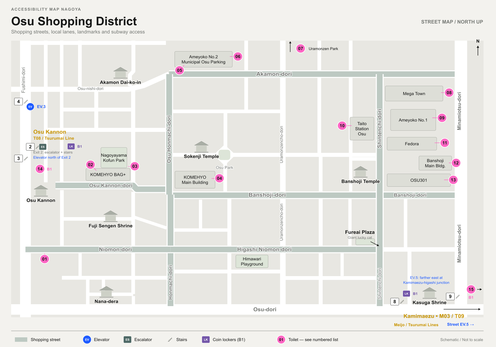
Schematic, not to scale — street centrelines are simplified and shop-internal passages are not shown. Markers 07 (Uramonzen Park) and 15 (Kamimaezu South Gate) sit just outside this crop and are shown with off-map arrows. Sourced from the official Osu district map, and the Osu Kannon and Kamimaezu station maps, checked 14 September 2026.